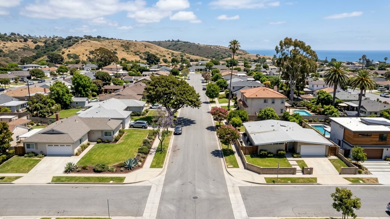
Torrance sits in the South Bay of Los Angeles County, with coastal access, historic neighborhoods, and major industrial centers all in the mix. Buying a home here means choosing between proximity to the water and a faster drive to the rest of the region.
Key takeaway
Torrance is its own city in Los Angeles County's South Bay, southwest of downtown LA between the 405 freeway and the Pacific. If you want that location with room to negotiate, start with condos, which took a median 51 days to sell recently. A single-family house is the alternative if you need a yard, but expect to compete for it.
Who this guide is for
You're considering a move to the South Bay and need to know where Torrance sits relative to work, LAX, and the coast before choosing a part of town and a type of home.
Where is Torrance, CA?
The location is clear-cut, but how you buy into it splits sharply by home type. In the 90 days ending September 30, 2026, single-family homes had just 1.5 months of supply, while condos carried 3.9 months. A buyer who cares more about the address than the yard has negotiating room that house hunters don't. The city covers 20.52 square miles of land. To identify specific postal boundaries, check the Torrance zip codes.
Torrance in Los Angeles County's South Bay
Torrance is an incorporated city, not a neighborhood of the City of Los Angeles. Formally incorporated in May 1921, it runs its own government, police, and fire departments. Its boundaries include:
- Lawndale and Gardena to the north
- The Harbor Gateway neighborhood of Los Angeles to the east
- Lomita, Rolling Hills Estates, and Palos Verdes Estates to the south
- Redondo Beach and the Pacific Ocean to the west
Torrance Beach is a 1.5-mile stretch of lifeguard-patrolled coast at the base of the Palos Verdes bluffs. Most of Torrance is inland, so "beach city" describes only a few neighborhoods.
Freeways and main roads through Torrance
The I-405 crosses the north side of Torrance and is the main route out of the South Bay. Pacific Coast Highway (State Route 1) runs through the southern part of the city. Hawthorne Boulevard (State Route 107) begins at Pacific Coast Highway and runs north through the center of town.
The I-110 runs near the eastern border, and its nearest interchange with the 405 is in neighboring Carson. The south and west sides reach the 405 only by surface streets. Which route you live near matters more than the city name.
How far Torrance is from downtown LA and LAX
Torrance City Hall is about 18 to 20 miles from downtown Los Angeles, roughly 22 to 30 minutes depending on route and traffic. It is about 11.5 miles from LAX by road, mostly via I-405 South, a drive of 16 to 50 minutes. Drive your commute at peak time before making an offer.
How to narrow your Torrance home search
Start with your daily drive. If it heads north toward LAX or downtown, begin with the freeway-side neighborhoods. If you mostly stay local, the coast side opens up.
Next, decide whether being near Torrance Beach or the Palos Verdes hills is worth a longer surface-street run to the 405. If it is, look at Hollywood Riviera, Walteria, and South Torrance.
Then choose between a private yard and a shared wall. A yard points to single-family homes. A shared wall points to condos and townhouses, where supply is deepest and you have the most room to negotiate.
Check official crime data for the specific part of town you're considering. For schools, confirm assignment with the Torrance Unified School District's address lookup rather than relying on a listing description.
Torrance neighborhoods on the coast and hills side
The southern and western edges trade immediate freeway access for the water and the Palos Verdes Peninsula, with Pacific Coast Highway and Hawthorne Boulevard carrying most trips. Prices generally reflect the shorter distance to the ocean.
Hollywood Riviera
Hollywood Riviera sits in the southwest coastal corner, where Torrance meets Redondo Beach and the bluffs drop to Torrance Beach. The sand is close, and Pacific Coast Highway is your primary way out.
The downside is that this is the part of Torrance farthest from the 405. A northbound commute starts with several miles of surface streets, so time the drive at 7:30 a.m. before you decide it works.
Walteria
Walteria sits at the base of the Palos Verdes hills, near Pacific Coast Highway and Hawthorne Boulevard. Buyers look here for the hills and the peninsula rather than beachfront living.
The downside is its proximity to Zamperini Field. Check the airport's noise contour map and visit when small planes are active to judge the sound for yourself.
South Torrance
South Torrance sits between the Riviera and Walteria, west of Hawthorne Boulevard, the coast-side option a bit closer to the city's central shopping corridors. Pacific Coast Highway and Hawthorne Boulevard carry most trips, so check how a listing's street connects to them at peak hours.
Torrance neighborhoods on the freeway side
The northern and eastern sections offer the fastest paths out of the South Bay. The trade-off is more distance from the ocean and closer proximity to the city's industrial zones.
North Torrance
The 405 crosses directly through this side of the city, giving North Torrance the shortest run to LAX and points north.
The downside is industrial land. The Torrance Refinery sits on the city's north-central side, surrounded by heavy and light manufacturing zones. Look up any address on the City of Torrance zoning map to see nearby industrial uses.
Old Torrance
Frederick Law Olmsted Jr. laid out downtown Torrance in 1912 as a planned industrial city. Today Old Torrance occupies the central-east part of the city, close to the 110.
The catch is the age of the housing. Older bungalows mean older plumbing and electrical systems, so request permit history and a sewer lateral inspection before removing contingencies.
Houses vs condos in Torrance
The same Torrance location costs and negotiates very differently depending on whether you buy a detached house or an attached home. If you're flexible on property type, you can save money and gain room to negotiate.
Single-family homes
Nearly half of single-family homes, 49.4%, closed above list price, at a median of $824 per square foot. The citywide price dip barely touches houses, whose median slipped just 0.8%. Budget for an over-list offer and clean terms rather than waiting for a discount.
Condos and townhouses
Attached homes are the cheapest way into the same location. Condos sold for a median $609 per square foot, about a quarter less than a house, and townhouse prices softened 4.7% year over year. The slower pace gives you room to ask for credits or repairs.
The catch is that HOA dues, reserves, and FHA approval vary by complex and can erase the price-per-foot savings. Before you get far into an offer, ask the HOA for:
- Current dues
- The latest reserve study
- The complex's FHA approval status
Torrance home prices at a glance
- All homes: median sale price $1,174,441, down 4.9% year over year; median $717 per sq ft; 34 median days on market; 2 months of supply (90 days ending 2026-09-30, 266 sales)
- Single-family homes: median sale price $1,329,470, down 0.8% year over year; median $824 per sq ft; 29 median days on market; 101.3% sale-to-list; 49.4% sold above list; 1.5 months of supply (90 days ending 2026-09-30, 177 sales)
- Townhouses: median sale price $871,510, down 4.7% year over year; median $613 per sq ft; 40 median days on market; 99.9% sale-to-list; 27% sold above list; 2.2 months of supply (90 days ending 2026-09-30, 49 sales)
- Condos: median sale price $692,929, up 2.7% year over year; median $609 per sq ft; 51 median days on market; 99% sale-to-list; 23.5% sold above list; 3.9 months of supply (90 days ending 2026-09-30, 35 sales)
Set your budget from the median for the home type you want, then use the guide to buying a home in Torrance and the cost of living in Torrance to plan for expenses beyond the purchase price.
Torrance, CA location FAQs
Is Torrance part of Los Angeles?
No. Torrance is a separately incorporated city in Los Angeles County, bordering the Harbor Gateway neighborhood of Los Angeles to the east.
What is Torrance, California famous for?
Torrance is known for its 1912 downtown planned by Frederick Law Olmsted Jr. It was also home to Toyota's North American headquarters from 1982 until the move to Texas in 2017. The Del Amo Fashion Center here was the largest shopping mall in the United States from 1981 to 1992.
Is Torrance, CA a wealthy area?
Housing costs sit well above national averages. The all-homes median sale price was roughly $1,174,441, and single-family homes topped $1.3 million.
How much is the Torrance Transit bus fare, and does it take TAP?
Yes, Torrance Transit takes TAP cards, the TAP LA mobile app, and Apple Wallet. The local cash fare is $1.00 and the L.A. Express fare is $2.00, with monthly passes at $35 local and $65 L.A. Express.
What is the sales tax rate in Torrance, CA?
The combined rate is 10.750%, up from 10.250% effective October 1, 2026.
Where does Torrance get its water?
Torrance Municipal Water serves about 78 percent of the city. The remaining areas are served by California Water Service, the Metropolitan Water District of Southern California, and the Water Replenishment District of Southern California, so confirm the provider for any address you're buying.
Where does Torrance airport fly to?
Torrance Municipal Airport-Zamperini Field is a general aviation airport with no scheduled commercial airline service. It supports flight instruction, aircraft maintenance, and charter flights; for airline travel, residents use LAX.
Sources
- Redfin: Data Center
- City of Torrance: About Torrance
- U.S. Census Bureau: QuickFacts Torrance city, California
- Wikipedia: California State Route 107
- iRide360: LAX to Torrance
- South Coast AQMD: Torrance Refinery Draft Fenceline Plan
- City of Torrance: Torrance Airport
- Torrance Transit: Fares
- California Department of Tax and Fee Administration: Sales Tax Notice
- City of Torrance: Water Services
- Wikipedia: Del Amo Fashion Center
- Wikipedia: Toyota Motor Sales, USA